I had neglected the SBP for about 6 weeks, and it was time to rectify this with another circular walk. As the forecast was good, I went into work early and finished by lunchtime. The journey to Rowbook took a little over an hour, and after parking up on the verge a little south of my start point, I was ready to begin the walk at 2.45pm. Being a weekday, I had both dogs with me.
 |
| Route out (northern branch) and back (southern branch) |
 |
| Cuckoo flowers on the verge |
I walked up Horsham Road for a couple of hundred meters to the driveway of Ridge and Bury St Austen’s farms. There were some lovely spring flowers on the verge. Turning west along the drive, the fields to the north were bright yellow with a flowering rape crop. At Ridge farm we passed a path junction – our return route would bring us back to this point later.
 |
| Looking across flowering rape fields to the barns of Ridge Farm |
 |
| Path junction at Ride Farm - our return route would bring us back to this point later |
The concrete driveway meandered between fields for about 2km and made for very easy walking – there were views to distant hill tops both north (Greensand ridge?) and south (Downs?). About half way along I passed Bury St Austen’s farm.
 |
| The winding concrete drive made for very easy walking |
 |
| Bury St Austen's farmhouse |
As the driveway swung due south towards Hermongers Farm, the path left the concrete as it maintained direction across a large field to reach a house called The Lodge. The gentleman owner was busy mowing the verge on his ride-on mower, and his missus was waiting on a bench close to their house with two cups of tea and slices of cake. She had thoughtfully provided a bowl of clean fresh drinking water for passing dogs which mine readily accepted, but unfortunately there was no tea/cake for me – perhaps I should have asked, she seemed very nice!
 |
| The barn opposite The Lodge |
 |
| Hermongers - early 19th C grade II listed |
Swinging briefly south, I followed the driveway to Hermongers, which included a farm and a separate, very impressive house, then turned west again to cross a small copse, which was alive with bluebells (gosh, how I love the woods at this time of year!). The footpath dipped down a little in the wood and then climbed up again through a rape field to cross a bridleway at a path junction.
 |
| Bluebell time - although not yet at their best |
 |
| Crossing a large rape field after emerging from Street Copse |
A narrow fenced path then took me to Holy Trinity church, Rudgwick. I actually took slightly the wrong route through the churchyard, but saved myself a few yards of road walking, as the correct route requires a short walk northwards along Church Street anyway.
 |
| On the path leading to Rudgwick |
 |
| Holy Trinity Church, Rudgwick |
The SBP left the village on a narrow fenced footpath between houses, and then crossed the corner of a small field (almost someone’s large back garden, I think). After walking through a very small path of woodland, I emerged onto Little Hawks Hill.
 |
| View NW from Little Hawks Hill |
 |
| Flooded clay pit just visible through the trees |
Hugging the field boundary I soon glimpsed water through the hedgerow to my left. A glance at the map revealed this to be a flooded clay pit working. Then a gentle descent took me to South Wood, where I met up with the Downs Link path, sharing its route for just 200m. The Downs Link is a 36.7mile footpath and bridleway linking the North Downs Way at St. Martha's Hill in Surrey with the South Downs Way near Steyning in West Sussex and on via the Coastal Link to Shoreham-by-Sea.
 |
| Heading for South Wood |
 |
| Meeting the Downs Link path |
Where the Downs Link headed north again, I continued west. The map shows a trig point in a clearing, but in fact the wood was more extensive than depicted by the OS map, and I couldn’t see it from the path. My walking friend, Dave Harris, who ‘collects’ trig points, would certainly have dived off into the undergrowth to find it, I’m sure!
 |
| On the Downs Link path |
 |
| Views SW |
Emerging into a large pasture field there were excellent views to the south west. In the grass there was clear evidence of recent cattle occupation (cow pats a plenty!), so it was no real surprise to come across a small herd of heifers once I could see into a small valley in the field to my left. Unfortunately, they were quite keen to come and say hello, so I was very pleased that we reached the field boundary (and escaped through a high, deer-proof kissing gate), before they reached us.
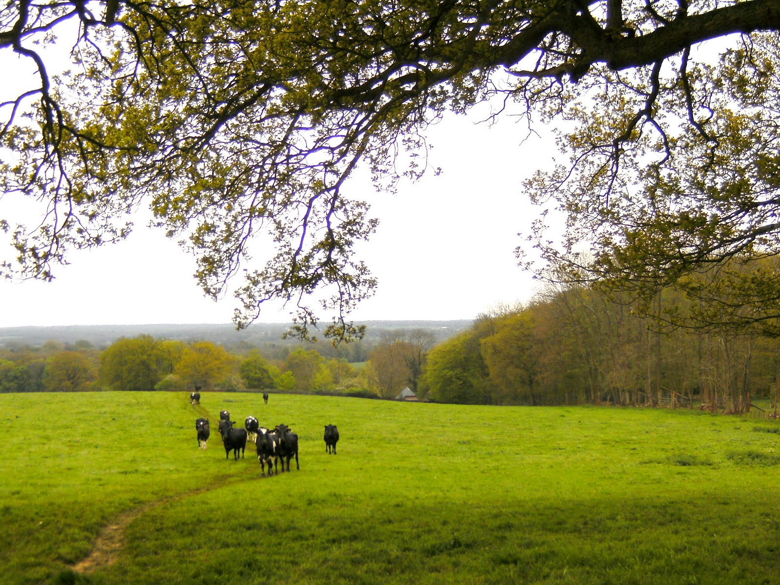 |
| Oops, here come the cows! |
As they all gathered round the gate, snorting at us, Jazz barked a warning at them. This spooked them wildly, and they all cantered off round the corner to join the rest of the herd in the far corner of the field. Quite a comical sight!
 |
| After Jazz saw them off, the cows run off to join their mates |
 |
| The path between deer fences |
I continued for a further ½ mile on a path hugging the edge of a wood, and bordered by a high fence. As we dipped down to cross a stream, Poppy seemed very interested at something to our left – perhaps she could smell the deer, as this was apparently a deer farm.
 |
| Dipping down to cross a stream |
When I reached Cook’s Hill lane, our short jaunt along the SBP was finished for the day – at just 4.2m this was the shortest section completed to date, although my return journey to the car was a further 6.2m.
 |
| On Cook's Hill Lane - the end of our short trip along the SBP today |
Highlights of the return trip:
- Along Cook’s Hill Lane, I suddenly spotted a solitary deer staring at me from the wood. The dogs didn’t see or smell it, and it didn’t move a muscle as I photographed it – it almost looked stuffed! I’ll have to check out if it’s still there when I return to do the next stage!
 |
| Is it real? |
- On the farm drive to Woodsomes Farm I met two groups of dairy cattle returning to their field after milking. Fortunately, on the first occasion I was able to get the dogs into an adjacent field through a gateway to allow the cows past, and on the second, by increasing our pace, we managed to reach the turn off onto the bridleway just before the cows reached us.
 |
| The cows returning to their field after milking |
- From a short road section along Lynwick Street I crossed back over the Downs Link path at ap point which clearly shows it to be an old railway line.
 |
| Looking down on the Downs Link path |
- After crossing a valley I passed through Rudgwick again. I had hoped to buy a snack somewhere, but it would appear from the map that the bulk of the village (and presumably the shops) are further to the south. I should have popped into Kings Head for a packet of crisps.
 |
| Back at Rudgwick village |
- Once across the next valley, the path continued through delightful woodland for about 1.5m. Towards the end, the sun finally made an appearance through the clouds.
 |
| Timber stacked between tree trunks, near Hyes Farm |
- On the final mile or so, the path swung north. We crossed a large arable field of winter wheat, where the path was not visible on the ground. Fortunately the crop was dry and the GPS ensured we maintained the correct direction.
 |
| Jazz attempts to climb a stile (in the end she squeezed under the fence on the right) |
- Despite having thought to myself earlier that the whole walk had been superbly waymarked, I managed to go a little astray right near the end, just after Old Ockley house, where I must have missed a sign directing me into a wood, and I wandered round in circles for five minutes or so trying to find the correct path. Again, the GPS usually gets me out of trouble on these occasions, as it did here. If you look at the map of the route at the top of this post, you will see on the tracklog where I circled round trying to find the correct path.
 |
| Back on track - looking back down the path I should have been on! |
- I rejoined the outward route at Ridge Farm and returned to my car in lovely evening sunshine, to complete a lovely walk.
 |
| The rape glows brightly in a shaft of evening sunshine |
- On the journey home, I stopped in Warnham village to photograph the church where I got married nearly 32 years ago (I was a child bride!).
 |
| Warnham Church |
I am pretty busy over the coming couple of months with walk (parts of Thames Path and Cotswold Way, and half of Wainright's Coast to Coast) and family related things, so it is likely I won't be able to contine the SBP until July. I WILL finish it this year though, even though it is getting progressively farther away from home and therefore less convenient for doing short sections. I guess at some point it will make sense to go westwards for the weekend and get a good section done.
This is looking very good! I am now following your lead as I needed some more local walks to sustain me over the summer. I hope you are enjoying your summer - the itineraries look fantastic!
ReplyDelete